
Zillis-Reischen
Zillis-Reischen | |
|---|---|
 | |
 Flag  Coat of arms | |
Location of Zillis-Reischen  | |
 Zillis-Reischen  Zillis-Reischen | |
| Coordinates: 46°38′N 9°26′E / 46.633°N 9.433°E | |
| Country | Switzerland |
| Canton | Graubünden |
| District | Viamala |
| Area | |
| • Total | 24.48 km2 (9.45 sq mi) |
| Elevation | 945 m (3,100 ft) |
| Population (31 December 2018)[2] | |
| • Total | 401 |
| • Density | 16/km2 (42/sq mi) |
| Time zone | UTC+01:00 (Central European Time) |
| • Summer (DST) | UTC+02:00 (Central European Summer Time) |
| Postal code(s) | 7432 |
| SFOS number | 3712 |
| ISO 3166 code | CH-GR |
| Surrounded by | Donat, Lohn, Mutten, Pignia, Rongellen, Salouf, Sils im Domleschg, Stierva |
| Website | www SFSO statistics |
Zillis-Reischen (Romansh: Ziràn-Reschen) is a municipality in the Viamala Region in the Swiss canton of Graubünden.
History[edit]

Zillis-Reischen was created in 1875 with the union of the previously independent municipalities of Reischen and Zillis.[3] Zillis was first mentioned in the first half of the 9th Century as Ciranes.[4] Reischen was first mentioned in 1219 as de Rexeno.[5]
The municipality site was certainly inhabited even earlier, as a Roman settlement and graves from the 6th or 7th century indicate. A treasure trove of 10th Century coins that were found near the village indicate that there was trade over the Viamala pass by this time.
The first church in Zillis dates from about the 5th Century. The three-apse church is from the 8th Century, and around 840 the parish church of St. Martin was first mentioned. In 940 King Otto I gave the Zillis Church to the Bishop of Chur. This gift did not include the church's property, four large farms in Schams and Rheinwald.
In 1473 the Viamala road over the Alps opened, which increased traffic on the Splügen and San Bernardino passes. The villages flourished with this increased trade. In 1530-35 Zillis and Reischen converted during the Protestant Reformation.
In 1818-23 the Viamala road was expanded with a wider road, which brought increased trade into the villages.
Geography[edit]
Zillis-Reischen is located in the valley of the Hinterrhein.
Zillis-Reischen has an area, as of 2006[update], of 24.5 km2 (9.5 sq mi). Of this area, 32.5% is used for agricultural purposes, while 42.8% is forested. Of the rest of the land, 1.8% is settled (buildings or roads) and the remainder (22.9%) is non-productive (rivers, glaciers or mountains).[6]
Before 2017, the municipality was located in the Schams sub-district, of the Hinterrhein district, after 2017 it was part of the Viamala Region.[7] In 1875, the municipality expanded with the unification of the previously independent municipalities of Reischen and Zillis.[8]
Demographics[edit]

Zillis-Reischen has a population (as of 31 December 2020) of 389.[9] As of 2008[update], 6.8% of the population was made up of foreign nationals. Over the last 10 years the population has grown at a rate of 6.7%.[6]
As of 2000[update], the gender distribution of the population was 52.6% male and 47.4% female.[10] The age distribution, as of 2000[update], in Zillis-Reischen is; 46 people or 13.9% of the population are between 0 and 9 years old. 23 people or 7.0% are 10 to 14, and 15 people or 4.5% are 15 to 19. Of the adult population, 23 people or 7.0% of the population are between 20 and 29 years old. 50 people or 15.2% are 30 to 39, 47 people or 14.2% are 40 to 49, and 37 people or 11.2% are 50 to 59. The senior population distribution is 34 people or 10.3% of the population are between 60 and 69 years old, 32 people or 9.7% are 70 to 79, there are 18 people or 5.5% who are 80 to 89, and there are 5 people or 1.5% who are 90 to 99.[11]
In the 2007 federal election the most popular party was the SVP which received 49.8% of the vote. The next three most popular parties were the FDP (23.7%), the SPS (18.1%) and the CVP (7.8%).[6]
In Zillis-Reischen about 70.3% of the population (between age 25-64) have completed either non-mandatory upper secondary education or additional higher education (either university or a Fachhochschule).[6]
Zillis-Reischen has an unemployment rate of 1.24%. As of 2005[update], there were 38 people employed in the primary economic sector and about 12 businesses involved in this sector. 106 people are employed in the secondary sector and there are 8 businesses in this sector. 52 people are employed in the tertiary sector, with 22 businesses in this sector.[6]
The historical population is given in the following table:[10]
| Year | Population |
|---|---|
| 1850 | 392 |
| 1900 | 263 |
| 1950 | 276 |
| 1960 | 315 |
| 1970 | 318 |
| 1980 | 252 |
| 1990 | 312 |
| 2000 | 330 |
Languages[edit]
Most of the population (as of 2000[update]) speaks German (79.7%), with Romansh being second most common (12.7%) and Italian being third ( 2.1%).[6]
| Languages in Zillis-Reischen | ||||||
| Languages | Census 1980 | Census 1990 | Census 2000 | |||
| Number | Percent | Number | Percent | Number | Percent | |
| German | 136 | 53.97% | 229 | 73.40% | 263 | 79.70% |
| Romansh | 104 | 41.27% | 72 | 23.08% | 42 | 12.73% |
| Population | 252 | 100% | 312 | 100% | 330 | 100% |
Heritage sites of national significance[edit]
The S. Martegn/St Martin's Church, the Cave under Hasenstein (a Roman cult site) and the Wildener- and Premoli-Bridges are listed as Swiss heritage sites of national significance.[12]
The first church in Zillis dates from about the 5th Century. The three-apse church is from the 8th Century, and around 840 the parish church of St. Martin was first mentioned. In 1130/40 the famous romanesque painted timber ceiling was added.
-
 Decorated ceiling in S. Martegn/St Martin's Church
 -
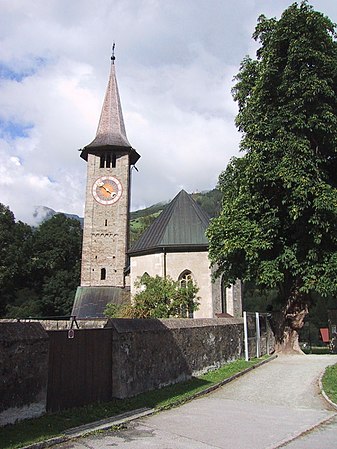 St. Martin's in Zillis
 -
 Vaulted ceiling of St. Martin's church


References[edit]
- ^ a b "Arealstatistik Standard - Gemeinden nach 4 Hauptbereichen". Federal Statistical Office. Retrieved 13 January 2019.
- ^ "Ständige Wohnbevölkerung nach Staatsangehörigkeitskategorie Geschlecht und Gemeinde; Provisorische Jahresergebnisse; 2018". Federal Statistical Office. 9 April 2019. Retrieved 11 April 2019.
- ^ Zillis-Reischen in German, French and Italian in the online Historical Dictionary of Switzerland.
- ^ Zillis in German, French and Italian in the online Historical Dictionary of Switzerland.
- ^ Reischen in German, French and Italian in the online Historical Dictionary of Switzerland.
- ^ a b c d e f Swiss Federal Statistical Office accessed 7 October 2009
- ^ Swiss Federal Statistical Office - Amtliches Gemeindeverzeichnis der Schweiz - Mutationsmeldungen 2016 accessed 16 February 2017
- ^ Amtliches Gemeindeverzeichnis der Schweiz published by the Swiss Federal Statistical Office (in German) accessed 23 September 2009
- ^ "Ständige und nichtständige Wohnbevölkerung nach institutionellen Gliederungen, Geburtsort und Staatsangehörigkeit". bfs.admin.ch (in German). Swiss Federal Statistical Office - STAT-TAB. 31 December 2020. Retrieved 21 September 2021.
- ^ a b Graubunden in Numbers Archived September 24, 2009, at the Wayback Machine (in German) accessed 21 September 2009
- ^ Graubunden Population Statistics Archived August 27, 2009, at the Wayback Machine (in German) accessed 21 September 2009
- ^ Swiss inventory of cultural property of national and regional significance Archived May 1, 2009, at the Wayback Machine 21 November 2008 version, (in German) accessed 7 October 2009
External links[edit]
- Official website (in German)
- Zillis-Reischen in German, French and Italian in the online Historical Dictionary of Switzerland.
- Reischen in German, French and Italian in the online Historical Dictionary of Switzerland.
- Zillis in German, French and Italian in the online Historical Dictionary of Switzerland.
- St Martin's official site
- St Martin in Zillis, Switzerland
| International | |
|---|---|
| National | |
| Geographic | |
| Other | |